


How to reach us
2-01 office,
117 Uritskogo Str.
Krasnoyarsk, RUSSIA
117 Uritskogo Str.
Krasnoyarsk, RUSSIA
- e-mail:
- info@sayanring.com
- Open hours:
- Monday-Friday 10 am-7 pm
- Sat 11 am - 4 pm
- Sun - day off
Belukha mount
Multa lakes
 The valley of the Multa River attracts tourists by the necklace of mountain lakes, situated as in the valley as near its tributaries – the Krepkaya River, the Poperechnaya River and the Kuyguk River. The nearby peaks of the mountains are covered with snow. Many small waterfalls flow down the Katun Mountain Range. All the lakes are situated in the Katun Reserve.
Lower Multa Lake is located at an altitude of 1710 m. The length is 2370 m and the maximum width of the lake is 900 m, the depth is 21 m. On the shore there is a small pebble beach. The place for camping is organized.
Middle Multa lake is a little bit less. The length is 1990 meters, the altitude t is 1740 m, the maximum width is about 750 meters, the depth is 8 m. The lake has the shape of a rectangle, the coastline is straight. Western and Eastern shores of the lake are the slopes of the ridges. The lake in the south meets the river Multa.
Between the Middle and Lower lakes the Multa River forms a beautiful and powerful cascade Shuma.
In 6 meters from the Middle Multa lake there is Upper Multa Lake, the wildest one of Multa lakes. The lake has an oval shape. The length is 1425 m, the width is 415 m, the depth is 47 m, the altitude is 1795 m. The northern part of the lake is swampy. To the bowl of the lake flow down 11 spectacular waterfalls (water drop of one of them is up to 60 m). Banks are covered by cedars. The waters of the lake reflect the snowy peaks of the nearby mountains.
The group of Multa lakes also includes lakes Poperechnoye, Upper Poperechnoye, Kuyguk and Krepkoye.
The glacier-fed lakes are the result of a moraine weir. In the vicinity of the lakes there are a lot of berries: blueberries, honeysuckle, currant, raspberry. Fishermen find here a fascinating fishing for grayling.
Multinskie Lakes are usually visited by tourists during trekking or cycling tours (mountain bikes). There are also combined tours, for example, horse and trekking tours, offering ascending the glacier and fishing.
How to get there: By car or by bus to the village Multa / by off-road vehicle to the village Maralnik-1 (the distance between the villages 10 km). Then a hiking trail begins, 12 km long to Lower Multa lake. Transfer by GAZ-66 or Ural is also possible.
Akkem lake
The lake is located at the foot of the northern slope of Belukha, is a natural monument and part of the National Park of Belukha. The lake is stretched from south to north, with the length of 1350 m, the width of 610 m, the average depth of 7.8 m, the altitude - 2050 m.
Akkem lake feeds from glacier meltwaters. On the banks larch and cedars grow. The water is muddy, gray and white. Water temperature does not exceed +4,5 ° C. Fish in the lake is not found. The lake is called a "dead" one. In calm weather, if no ripples on the lake, a reflection of a snow-white Belukha can be seen in the calm water.
On the north-western shore of the lake there is a meteorological station Akkem, one of the oldest in the Altai. The observations are carried out since 1932. On the left bank of the lake there is a camp and an emergency station.
Through passes Burevestnik and Riga tourist you can reach Kucherla lake on foot and through the pass Karaturek - on foot or by horseback.
How to get there: 45 km from the village Tyungur. The first option - from Tyungur through the pass Kuzuyak to the valley of the Akkem river, further upstream to Akkem lake. The second option - from Tyungur upstream the Kucherla river, then through Karaturek Pass (3060 m) to the valley of Akkem lake and Akkem river. Most common are round-tours with ascent the river Akkem and descent the river Kucherla, so you can see a lot of interesting sights during just one route.
Kucherla lake
The highland lake is located at the foot of the northern slope of Belukha, in the upper reaches of the river Kucherla. It’s one of the most beautiful lakes in the Altai Mountains. The altitude of 1790 m above sea level. Length - 5 km, width - 700 m, depth - 55 m. The lake is of glacial origin. From the east and west around the lake there are many tops of 3,000 m. The slopes are covered with forest. The lake is home for grayling and rainbow trout. The color of water is turquoise. In contrast to the "dead" Akkem lake Kucherla lake is called "water of life". In the vicinity hunting for mountain goats is possible.
How to get there: From the village Kucherla to the lake Kucherla there is a horseback riding trail, 34 km long. From the village Tyungur to the lake Kucherla there is a hiking trail, 40 km long.
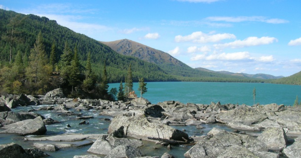
Taimenye lake
It is the largest lake in the basin of the Katun River. It is situated on the south slope of the Katun Mountain Range at a height 1570 m. It’s a part of Katun reserve, on the banks of the lake there is a reserve’s station. The lake is extended from the northeast to the southwest. The length of the lake is 5420 m, maximal width is 1080 m and the death is 68 m. The depth decreases rapidly along the north-western and south-eastern sides, growing up to 40 m in the 50-60 meters from the shore.
The water of the lake has muddy tint that is connected with waters taken from melting glacier. Visibility is not more than 3.2 m deep. In summers the water on the surface warms up to 14˚C, in spite in summer the sun shines very brightly in the vicinity of the lake.
Two rivers flow into the lake, which originate in ice cirques of the Katun Mountain Range. There is a waterfall on one of the rivers, 5 m high.
Since 1978 Taymenie Lake is approved as a monument of nature.
Taimenye Lake is an ideal place for fishing grayling and lenok. Lenok is similar to taimen, lake explorers mistook lenok for trout and gave the name to the lake.
The distance from the lake to the nearest settlements is about 100 km. The visitation of the lake is included in all main horse and combined tours in the area. The easiest way to reach the lake is by motor boat or cutter up to the reaches of the Ozernaya River, further the tourists go on foot or by horses along this river (25 km). Also you can reach Taimenye lake by horses from the village Maralovodka or Upper Uymon, but it takes about 3 days.
