


How to reach us
2-01 office,
117 Uritskogo Str.
Krasnoyarsk, RUSSIA
117 Uritskogo Str.
Krasnoyarsk, RUSSIA
- e-mail:
- info@sayanring.com
- Open hours:
- Monday-Friday 10 am-7 pm
- Sat 11 am - 4 pm
- Sun - day off
North-Chuysky Range
Aktru valley
Aktru valley is a major center of glaciation (the total glacier area of about 16 km²). There are several glaciers, the largest of which are the glaciers Big and Small Aktru, Left and Right Aktru and others. The valley is named after the Aktru river (from the Altai language "white house"), the origins of which are located on the surrounding glaciers. The valley is surrounded by high snow-capped mountains higher than 3,500 meters. The top Aktru-Bashi (4075 m) is the highest point of the district, the second highest peak of North-Chuysky range.
Aktru valley is one of the centers of the Altai mountain climbing, offers routes from the simplest 1A to the most difficult 5B. The first mountaineering camp appeared here in 1938. Today it is a year-round tourist camp for not only climbers, but also for all nature lovers. In summer a mountaineering school is operated here, everyone can take a course of mountaineering skills. Besides, there is a rescue service, small shop, pharmacy, banya, shower, dining room, cabins for accommodation, power supply, equipment rent service, instructor service.
Beginners can climb tops of Kyzyl-Tash (3486 m), Karatash (3534 m) and Dome of three lakes (3556 m), which offer great views of the Altai Mountains. You can take also a walk to the nearest glacier Small Aktru (6 km from the camp), the lower edge is located on the forest level. Spectacular views offers the pass Teacher (3100 m): beautiful panorama of peaks Aktru-Bashi and Kurkurek, Kurai steppe and Kurai mountain range.
In addition, Aktru valley is popular among freeriders. With a special physical and technical preparation you can go skiing or snowboarding in both winter and summer.
How to get: Along Chuysky tract to Kurai village, then to the south through the steppe by a unpaved road (23 km) in the direction to the snow-capped mountains, to the cordon, which is equipped with a parking lot. On the way you will have to overcome several fords. From here to the camp Aktru 8 km on foot or by all-terrain vehicles (UAZ, Ural, etc.).
See Trekking tour Towards the Aktru valley


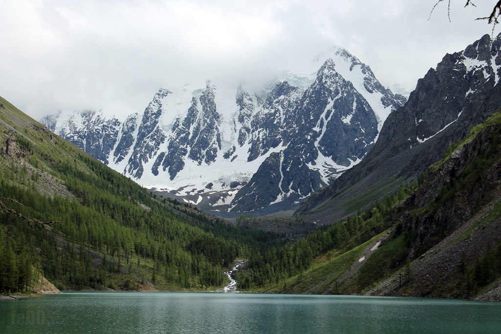
Blue lake
Blue lake is a starting point for climbing several tops (Kyzyltash, Aktru-Bash, Stazhery, Radistov, Students, Yunost, Aktru, etc). The lake is located 12 km away from the camp Aktru at an altitude of 2840 m. From the north and north-east the lake is framed by steep rocky slopes, the southern shore of the lake is flatter, formed by glacial moraine. On the shore of the lake a hut of glaciologists is situated. The water in the lake, even in the hot summer, does not rise above + 2C. The ice on the lake can be up to the beginning of June. It freezes in the second half of September. The depth of the lake is 14 meters. The water is clean, drinkable.
Tours from the camp Aktru to the glacier Left Aktru and Blue Lake are the most popular route for the mass tourist and for acclimatization for further ascents. This route can be passed accompanied by an instructor or independent - throughout the route every 100 meters there are pyramids of stones composed by other tourists, showing the way. The trail runs along the left bank of the river Aktru, on the slope of the mount Kyzyltash. By the way you can see the panorama of the glacier Small Aktru, which is located between the peaks Karatash and Dome and occupies steeply falling glacial valley. You can admire this glacier both near and far. The trail follows to sheepback rocks - two rocks with smooth peaks, polished by the glacier activity, on the right side of them there is a deep trough, along which you can climb to the glacier Big Aktru. Big Aktru Glacier has an area of over 11 thousand sq. m, is about 8 km long, is the main and largest of Aktru glaciers. In some places the ice thickness reaches 350 meters. At the glacier bottom, at a distance of about 1 km from the edge of its tongue, at an altitude of 2840 m above sea level, there is Blue Lake.
Shavla lakes
Shavla lakes are one of the most beautiful places in the Altai Mountains, located in the heart of North-Chuysky range. Snow-capped peaks Dream, Beauty, Fairy Tale (up to 3700 m) tower above the lakes. In clear windless weather they are fully reflected in the vast mirror of the lakes. Surrounded by high snow-capped peaks you will meet turquoise Shavla lakes with truly bright colors. These places will surely amaze you with its grandeur and pristine beauty.
Upper Shavla lake is located near a large Shavla glacier descending to the northwest from the one of the peaks of the North-Chuysky range. The lake is located at an altitude of 2164 m. Its length is 1500 meters, width is 500 m. Flat and stony shores. The lake has a peculiar bright turquoise color, due to a significant impurity of glacial turbidity.
Lower Shavla Lake is located 5 km from the Upper lake on the altitude of 1983 m. It is 800 m long, 500 m wide. The lake is in the process of silting. In the middle of the lake there are vast shoals, partly overgrown with reeds. Only along the shores of lakes (especially the right one) large open space of water and tourist camping spots are located.
How to get: From Chibit village (located on Chuysky tract) cross the wooden bridge over the river Chuya follow the trail uphill leading to the lakes. The bridge is located 50 km from the Chuysky tract. Move to the confluence of the right and left Shavla rivers. Then along the right bank of the Shavla river. On the last kilometers the trail goes steeply up, overcoming powerful rock moraine, which formed the lake. Distance from Chibit village to Lower Shavla Lake is about 35 km.
Maashey valley
Until quite recently Maashey valley was famous for its lake Maashey. The lake was formed as a result of a landslide, blocked the river valley a little over 100 years ago. Not long time ago, the lake has disappeared, the reason for that was the usual natural phenomenon: as a result of heavy rains July 2012 the lake’s dam was washed away. The lake water merged with the river Maashey.
Maashey valley is at an altitude of 2000 m, surrounded by cedar forest near the peak Maayshey-Bash (4177 m) and the glacier Maashey. The highest peaks of the North-Chuysky range are clearly visible from the valley: Karagem peak (3750 m) and Maashey peak (4173 m).
Maashey Valley is the best place for alpine climbing and hiking, offers some radial routes to the foot of the glaciers, visiting mountain lakes (including Shavla lakes) and waterfalls. Alpine routes of difficulty grade 5 are also possible.
How to get: Along Chuysky tract to Aktash village (797 km) on the right there is a camp site "Meny" - the starting point of all hiking and horse riding trails. From the camp move on foot or on horseback to the Chuya River, then downstream to the confluence of the rivers Maashey and Chuya. Cross the Chuya river by an old wooden bridge and head upstream the Maashey river. Cross the river Karakabak, continue to rise Maashey river upstream to the former lake. The distance from the camp "Meny" - 20 km (2 days).

